CASE STUDY
PROJECT BRIEF
Climate change is increasing environmental variability, affecting landscape responses to management activities, including forest restoration efforts. Monitoring landscape conditions before and after restoration is essential to evaluating restoration success and informing adaptive management, but on-the-ground monitoring has historically been costly and limited in scale. In collaboration with the National Forest Foundation, the Analytics Lab at CSP is developing a remote sensing-based approach for pre- and post-restoration monitoring, addressing some of the constraints of typical field-based monitoring and augmenting the capacity of conservationists to evaluate- and adapt- their restoration approaches to keep pace with global change.
PROJECT DESCRIPTION
Ecosystems in the Western US are experiencing the negative effects of climate change, land use change, and invasive species. To address ecosystem degradation, restoration and management strategies are being widely deployed to improve ecological resilience and enhance landscape connectivity. Monitoring is essential to ensure that these restoration and management approaches achieve their desired goals and to guide adaptive management, subsequently improving outcomes. Unfortunately, many projects suffer from limited support for long-term monitoring, complicating the establishment of both pre-restoration baseline conditions and tracking post-restoration ecosystem response.
Remote sensing provides a novel way of integrating multimodal, multi-scale datasets to enhance ecosystem monitoring capabilities and address some of the constraints of on-the-ground monitoring. By providing more frequent and longer-term observations over many sites at the same time, remote sensing can provide a more comprehensive and scalable perspective on restoration efficacy than from field-based monitoring alone.
In partnership with the National Forest Foundation, the Analytics Lab is developing an approach leveraging remotely sensed data to monitor the outcomes of forest management treatments in the Truckee River watershed. This approach is offering new perspectives on the ‘baseline’ conditions and post-restoration responses of key habitats, illuminating the ability of restoration efforts to achieve desired outcomes and promote stable, resilient ecosystems and empowering managers to make informed adaptive management decisions.

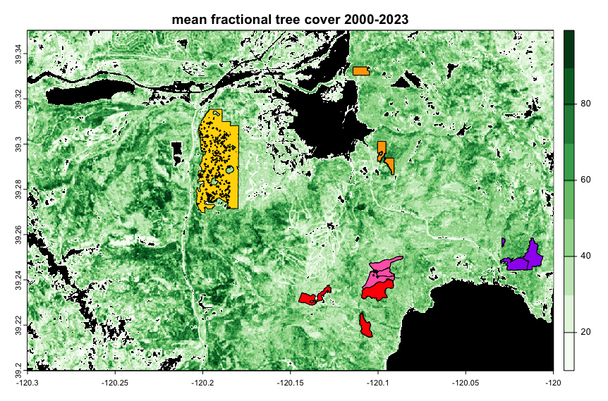
Figure 1. Study sites within the North Tahoe region at which fuels reduction work was implemented between 2005 and 2023. Sites are as follows, from west to east: Big Jack East (yellow); Redside (red); Fiberboard (pink); Glenshire-Brockway (orange); Yeti (purple).
KEY PARTNERS INCLUDE


Ben Letcher, USGS Ecologist